W

X

Thursday, August 29, 2013

New Weather Wire Feed Confirmed

The NOVRA S300N receiver settings, for Weather Wire, in the previous blog post have been confirmed.  I was able to receive data from the new Weather Wire feed tonight.

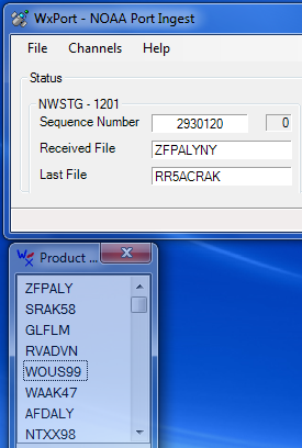
I made some modifications to WxPort (our NOAA Port ingest program) to receive the data stream.  The stream is in standard SBN format, so I did not have to develop a new ingest routine.

The following picture shows the stream being received and processed by Weather Message.


I plan to update the existing WxWW2000 ingest program to support this feed.

Tuesday, August 27, 2013

Novra Receiver Settings

I have been trying to receive the new WeatherWire stream using my Novra S300 receiver.  I thought it was as simple as adding PID 201 to the Novra receiver.  After further research I found that some of the other receiver settings would have to be modified.

The following summarizes the settings for Weather Wire and NOAA Port.

Setting 
NOAA Port 
Weather Wire 
 Frequency
 1154
 1154
 Modulation
 DVBS2
 DVBS2
Coding
 2/3 8 PSK
 1/3 QPSK
 Symbol Rate
 15.120
 15.120
 ISI
 13
 2
PID
 101
102
103
104
105
 201

Based on this information, it does not appear that you can receive NOAAPort and WeatherWire from the same receiver at the same time.

Wednesday, August 21, 2013

New Weather Wire Service Coming this Fall

The National Weather Service issued a Service Change Notice that outlines the new Weather Wire Service.  It appears that Weather Wire will be on the same satellite as NOAAPort.  It will use the same receiver as NOAAPort and share the transponder.  The information that has been posted indicates that it will use PID 201.

Here is a picture of the Novra S300 receiver used for NOAAPort.


I am interested to see what data will be on the Weather Wire channel.  The NOAAPort stream already contains more data than the current Weather Wire feed.  The website indicates that they will be providing an internet feed based on XMPP.

It may be possible to modify the WxPort (NOAAPort) ingest engine to receive the data from the satellite.  I will know more after seeing the data stream.  The WW2000 (Weather Wire) ingest will have to be rewritten to receive the XMPP data stream.

Service Change Notice 13-52
National Weather Service Headquarters Washington DC
722 AM EDT Tue Aug 20 2013 
 
To:        Subscribers:
           -NOAA Weather Wire Service
           Other NWS Partners, Users and Employees 
From:      Craig Hodan
           Chief, NWS Dissemination Systems Branch  
Subject:   New NOAA Weather Wire Service (NWWS) During 2014   
NWS is continuing the upgrade of NWWS to disseminate weather products to the public. A new NWWS will be commissioned during 2014. The new NWWS will operate concurrently with the present NWWS system until the NWWS system contract ends March 2014, at the earliest. For the latest news and information about this change, please consult the Weather Wire website at: 
    http://www.nws.noaa.gov/nwws/news.html  (Corrected Link)  
The new system will allow C-band satellite users to continue to use outdoor antennas they have in place, which will not require re-pointing but will require a new satellite receiver, new Low Noise Block Converter (LNB), and new or modified weather data processing/display software. Internet (Open Interface) users will need the new or modified processing/display software.   
The current NWWS system, operated under contract with Computer Sciences Corporation (CSC), will continue to operate into 2014.  CSC may or may not continue Weather Wire satellite and open-interface services after government contract termination.   
Updates will be posted on the NWWS website as it become available. For more information please contact: 
   Gregory Zwicker, NWWS Program Manager
   Operations Division
   NWS Office of Operational Systems
   Silver Spring, MD 20910
   Gregory.Zwicker@noaa.gov   
National Service Change Notices are online at:
     http://www.weather.gov/os/notif.htm   
$$

Monday, August 12, 2013

Radar Layer in WxMap

I had some time tonight to test loading a radar layer in WxMap.  I knew that the GIS engine would support graphic layers, I just have not had time to test the capability.

Here is a snapshot of the test program.


This shows the KMXX radar image overlaying West Alabama.